If a civil engineering firm were to measure a section of a busy street in the Capital Region for an upcoming project, they could survey the road — even during rush hour — with ease, using an advanced laser scanner. With this new technology, an engineer can capture every detail of the street and even take measurements as if the traffic had disappeared.
If a civil engineering firm were to measure a section of a busy street in the Capital Region for an upcoming project, they could survey the road — even during rush hour — with ease, using an advanced laser scanner. With this new technology, an engineer can capture every detail of the street and even take measurements as if the traffic had disappeared.
Advances in computer and laser scanning technology are allowing engineers and surveyors to scan buildings, bridges and roadways — including the surrounding topography — with incredible accuracy and measure the components right at their desks.
Traditional surveying methods involving tape measures and global positioning systems can take up to three people to assess the components of a structure, which, depending on the scope of the project, can take weeks. And often crews are forced to return to the site several times to re-measure certain aspects of the site that were originally missed.
But with advanced laser scanners, one person can measure up to 500,000 points per second, rapidly connecting the dots of a three-dimensional image for a precise understanding of spatial relationships, says Don Woolley, principal at Sacramento-based Rick Engineering Co.
“You can capture the entire site in 3-D. If you need to re-measure a spot from the site, you don’t have to go back,” says Tom Cardenas, scanning specialist at California Surveying & Drafting Supply Inc.
The comprehensiveness and accuracy of the images save time and money for firms that can afford the upfront cost of the technology. Labor costs are cut by more than two-thirds using the laser scanners, according to Chris Pechacek, virtual design construction director for McCarthy Building Cos. Inc.
But the scanners themselves range in price from $40,000 to $150,000 for tripod-based models.
In addition to saving time, the scans allow engineers to analyze data and evaluate structural performance, from the levelness of a floor to the soundness of beams. That way, they know in advance if any remediation is required.
The precision of a laser scanner in measuring a building’s original and current structure gives mechanical engineers an inside view of a wall or ceiling with its electrical wiring, plumbing, fixtures and ducts. These results can be used to more easily install a central heat and air system, for example It also provides architects with details to design a complex remodel. This upfront knowledge reduces mistakes, change orders and redesigns.
If done correctly, the building scans can prove invaluable to facility managers in sensitive environments such as prisons or hospitals. In a hospital, for example, without a laser scanner, even attaching equipment to a wall can be tricky, and sometimes it’s necessary to cut a wall open. When this occurs, engineers must coordinate with medical staff and representatives of Infectious Disease Control to move patients.
“Operations will have this (scanned image), so they will know exactly where backing in the wall is or where the conduit stops if they need to move fixtures or attach things to the wall,” says Simon Gregson, project director at McCarthy. “They won’t have to open a wall or a ceiling and disrupt patients or operations.”
At the California Department of Transportation, Senior Transportation Surveyor Kevin Akin says engineers can use the technology to detect whether a bridge is sagging or to identify exactly where repairs should be made in a roadway. When working on heavily trafficked freeways and high bridges, Akin says the laser allows a surveyor to measure the structure or topography from a distance.
“One attraction to this technology is not having to be on the
surface of the pavement on roadways … and getting the data
faster,” Akin says. “It also helps us to not have as many lane
closures, so there is less impact to the public.”
Rick Engineering
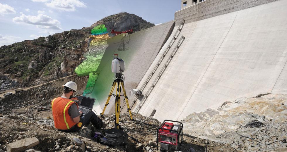
San Vicente Dam Raise Project
At the San Vicente Dam Raise Project in San Diego, Rick
Engineering used a laser scanner to find unexpected project
constraints during construction. While installing an outlet pipe
at the base of the dam, construction managers saw a skew in the
pipe. Using the laser scanner, the construction managers captured
the pipe conditions, and reported the problem back to engineers
to plan for installation of a new segment of pipe. Using the
laser scanner to correct the problem allowed Rick Engineering to
assist the abutment excavation team without causing delay in the
construction schedule.
Rick Engineering
Kaiser Permanente / San Diego Medical Center
Rick Engineering did a laser scan for Kaiser Permanente Medical
Center in San Diego to prepare for an upgrade to their
angiography room. The scan was critical because it was impossible
to determine from paper construction plans the ideal location of
proposed conduits and structural reinforcements. The laser
scanner captured 3-D coordinates of existing conditions,
including mechanical, electrical, plumbing, structural and
architectural features to create an accurate model. Utilities
were then coordinated with existing conditions inside the
construction area to facilitate the upgrade.
Caltrans Highway WX Freeway viaduct
After crossing Interstate 5, Interstate 80 runs on top of an
embankment between W and X Streets; this was originally known as
the WX Freeway. This image of the WX Freeway viaduct is made up
of 18 million points collected with a stationary laser scanner
mounted on a tripod. Engineers used the information to assess the
structural conditions prior to planning a potential widening and
pavement overlay project. Because of restrictions on the use of
lane closures and a short time frame, a mobile scanner was used
to survey the bridge decks while driving at highway speeds,
reducing the need for lane closures and traffic exposure. greatly
increases safety for engineers who are no longer required to go
on the roadway itself.
Recommended For You

Brain Power
Research and development is the foundation for regional manufacturing growth
Like an oil derrick with arms, the school-bus-yellow robot is the center of attraction in an otherwise colorless room dominated by metal castings and concrete floors. Moving like a mime on a street corner, the robot picks up a metal casting, holds it to a computer-run camera and then places the part and the fixture that holds it on a machine for tooling.


