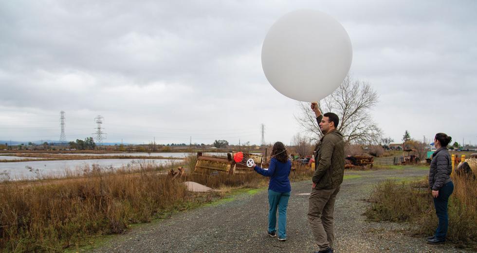
One rainy morning last December, John James stood outside holding a big white balloon, which looked like a perfect target for a lightning strike. Next to him, Carly Ellis, a field researcher with the UC San Diego Scripps Institution of Oceanography, asked a group of spectators if they were ready. Then, all together, they counted down: “Five, four, three, two, one.”
Not a second later, James, water operations projects manager for the Yuba Water Agency, released the balloon. “Whew, that went fast!” said an onlooker as the balloon shot up, snatched by the winds, and flew into gray clouds, the attached sensor flapping like a tail.
After a minute or so, the balloon disappeared, but the sensor kept sending data — temperature, pressure, moisture, wind — in real time to researchers on the ground. The balloon would rise until it reached a max altitude of 25,000 meters (15.5 miles), at which point it would pop and a small parachute would deploy, carrying the sensor safely back to the ground, collecting more data on the way down.
The event was the first weather balloon launch from a Yuba Water Agency site near Beale Air Force Base. But it will not be the last. During atmospheric rivers, scientists plan to release a balloon every three hours from this point to collect data. And the more data, the better, because understanding the structure of these storms can help with forecasting and flood control.
“The idea is we’re looking for science to provide answers to managing one of the most precious resources the state has, which is water,” James says months later, as he explains the water management mission to Comstock’s.
“The idea is we’re looking for science to provide answers to managing one of the most precious resources the state has, which is water.”
JOHN JAMES WATER OPERATIONS PROJECT MANAGER YUBA WATER AGENCY
In winter months, atmospheric rivers (such as Pineapple Express storms, which originate near Hawaii) come barreling in from the Pacific Ocean to batter the Western states. They’re like that unpredictable relative that drops by on short notice: making messes, causing spills, breaking things. Over a 40-year span, these storms caused roughly $1.1 billion in damages annually to California and 10 other western states, according to a study published in the journal Science Advances.
For decades, flood management involved dumping water from the reservoirs, which usually then flows into rivers toward the ocean, to make space for flood waters. It was a “better safe than sorry” strategy to protect flood-prone areas. But sometimes the rains never came, so that water, which could have been used to supply homes and farms, was lost.
Following the weather balloon launch in Yuba County, 2020 marks the beginning of the field campaign for Forecast Informed Reservoir Operations, or FIRO, a new water management strategy and collaborative effort by various agencies. The idea is that, in the face of climate change, environmental stress and population growth, advanced technology can lead to enhanced weather forecasting, which could make a huge impact in preventing floods and keeping reservoirs full.
‘Forecasts Aren’t Reliable’
Researchers are already using radar aimed at the Sierra Nevada and dropping sensors from military planes above storms in the Pacific Ocean. They will check moisture levels in the soil to see how much is absorbed. Weather balloons have been used for a long time, released by the National Weather Service every 12 hours at sites across the U.S., including three in California. But now, researchers plan to send them up more frequently during storms from strategic sites in the state. With better tools at their disposal, agencies can monitor atmospheric rivers and plan accordingly, says Anna Wilson, field research manager for the Center for Western Weather and Water Extremes at Scripps.
“It is so important for California’s future as we start to get less snow, more rain, more intense storms, and swings between wet and dry years becoming more severe,” Wilson says. “We need to use everything that’s out there in service of this pressing problem of Western water.”
Across the U.S., many large dams were built in the mid-1900s, when weather forecasting was low-tech. Predictive tools have become more advanced, but many water control manuals are stuck in the past. The U.S. Army Corps of Engineers, which manages flood risk across the country, partially paid for the construction of the major reservoirs so it has dictated how to operate portions of the reservoirs set aside for flood operations. The process, before the days of satellites and modern radar, was simple: If the water level crossed a specified line on the diagram, water managers were supposed to release water.
In the 1970s, Joseph Countryman was head of reservoir operations for the Corps in Sacramento. With the diagram being so crude, he advocated to incorporate forecasts. But the chain of command, which flowed up and eastward to Washington, D.C., didn’t want to bank on weather predictions to manage floods, he says. “‘Yes, the logic is great,’” Countryman recalls being told, “‘but the forecasts aren’t reliable.’”
Countryman, who left the Corps in 1987 and was president of MBK Engineers in Sacramento from 1988 until 2011, consulted with various officials in California. Discussions about updating water control manuals continued up to a few years ago when FIRO started gaining momentum. But Countryman, now a private consultant and member of the Central Valley Flood Protection Board, cautions too much optimism about the use of forecasting procedures too fast. Not all reservoirs can fully take advantage of FIRO yet.
“That is what people have to keep in mind,” Countryman says. “This isn’t a cure-all for all situations. Many reservoirs would have to be retrofitted. … In some cases, downstream channels would need to be enlarged.”
The reservoir would need to be able to release water quickly with a large outlet capacity. For instance, Folsom Dam has the ability to release water at 160,000 cubic feet per second. Compare that to New Don Pedro Dam on Tuolumne River, which can only release 9,000 cubic feet per second, or Friant Dam on the San Joaquin River, which can only release 8,000.
“I’m a big believer in this technology,” Countryman says, “but I don’t like to see things oversold.”
A Long Uphill Battle
Yuba County is still feeling the pain from floods and levee failures in 1986 and 1997. The economy hasn’t fully recovered, James says. He points to the former Peach Tree Mall (now called the Feather River Center) in Linda, which never bounced back after being submerged 34 years ago. The risk of flooding and potential high costs for flood insurance have deterred population growth in Yuba County since the floods, James says, adding that studies count almost $4 billion of damageable property downstream in Yuba County alone ($12 billion in the Yuba-Sutter region).
Last year, the Yuba Water Agency, with Scripps and the California Department of Water Resources, launched FIRO projects at New Bullards Bar and Oroville dams to improve forecasts and reduce flood risk. A secondary spillway is also in progress at New Bullards Bar Reservoir, set to be completed by 2024-25. According to James, FIRO provides a “climate resiliency tool” to help reduce flood risk and potentially increase water supplies for stakeholders (residents, farmers, fisheries, aquifers, etc.). Through the FIRO process, James expects the U.S. Army Corps of Engineers will obtain the data needed to update its rules and regulations, allowing for more flexible water management.
The same strategy is in effect at Folsom Dam. It became a successful FIRO project with the construction of the auxiliary spillway, substantially completed in 2017. The water control manual, revised in June 2019, includes operation rules that implement FIRO.
“For 12 years now, it has been a long uphill battle,” says Michael McMahon, a senior hydrometeorologist with HDR engineering in Denver, who helped oversee FIRO projects at Folsom Dam and at Lake Mendocino. “The science of hydroforecasting finally caught up with the need to better and more efficiently operate our reservoirs.”
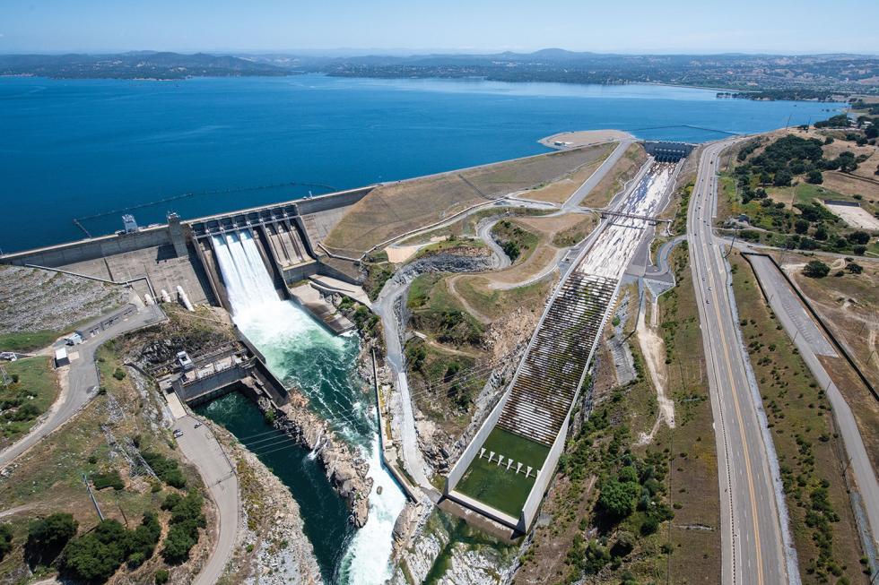
The auxiliary spillway (seen on the right) at Folsom Dam,
completed in 2017, will help dissipate energy as water flows into
the American River. It is expected to improve flood management at
the reservoir, where water can be released at 160,000 cubic feet
per second. (Photo courtesy of the California Department of Water
Resources/Florence Low)

The $900 million auxiliary spillway (also known as the Joint Federal Project) is described on the U.S. Bureau of Reclamation’s website as including “a 1,100-foot-long approach channel from Folsom Reservoir, a concrete control structure with six bulkhead and six radial gates, a 3,100-foot-long spillway chute, and a stilling basin” that helps dissipate energy as water flows out into the American River. This spillway is expected to improve flood management at Folsom Reservoir, but FIRO implementation in general “must be tailored on a case-by-case basis to maximize water supply, flood risk, environmental, and other benefits,” says Micheal Konieczki, senior hydrologic engineer with HDR in Sacramento.
Predicting the Future
Meteorologists say the skill of their forecast has improved by about one day per decade. Twenty years ago, the three-day forecast had the accuracy of today’s five-day forecast. Advanced technology has the potential to make accurate weather predictions more than two weeks out. Artificial intelligence and machine learning tools could be the key to unlocking greater forecasting potential, says Jeanine Jones, interstate resources manager of the California Department of Water Resources.
The National Weather Service bases predictions on dynamic models using high-performance (and highly expensive) supercomputers. With a grid of the globe, they run various simulations to see how a weather pattern in one area might affect another area. Before supercomputers, researchers did statistical modeling. This process, which uses statistics based on historical data to project outcomes, requires less computing resources, which makes it cheaper.
Machine learning methods use algorithms to examine huge amounts of data to make improvements. In 2019, DWR initiated a pilot with NASA to see if new techniques, including machine learning, can be used to improve and extend forecasting capabilities. It is still in progress. And it will take time to evaluate the data.
“In weather forecasting, you always have the possibility of getting the right answer for completely the wrong reasons,” Jones says.
With limited federal funding going to the National Weather Service, the approach of combining statistical modeling and machine learning with dynamical modeling could be a cost-effective solution, she says. For example, one technique could be using statistical modeling to post-process the output of a dynamical model.
In 2019, researchers at the Center for Western Weather and Water Extremes published a paper in Geophysical Research Letters titled “Improving Atmospheric River Forecasts With Machine Learning.” They wanted to explore how machine learning could reduce error in numerical weather forecasts regarding elements of atmospheric rivers. The study presents a forecast post-processing method that modifies forecasts by examining historical forecast errors from the National Centers for Environmental Prediction’s Global Forecast System and correcting for those errors.
The future looks bright for integrating artificial intelligence and machine learning into forecasting models. But any progress will require more research funding. Jones hopes the various partnerships and pilots show improvement for longer lead times. In the meantime, she says, adding more tools (statistical modeling and machine learning) to existing models can be implemented sooner and for less money in terms of supercomputer resources.
“Twenty years from now, when maybe they have figured out how to make the world’s biggest supercomputer the size of your iPhone, maybe we’ll get there,” Jones says, “but we’re not there yet.”
—
Stay up to date on business in the Capital Region: Subscribe to the Comstock’s newsletter today.
Recommended For You

Delta Blues
The battle over water has been fought to a standstill, but there’s hope that science and technology will make voluntary agreements by all sides possible
For decades, the California water debate revolved around one metric: unimpeded flow, which is the amount of water in the river and streams. While flow is still without doubt the key issue, it is no longer the only one.

Going With the Flows
McGeorge School of Law professor Jennifer Harder on water issues, laws and uses
Professor Jennifer Harder is the co-director of the Water & Environmental Law program at McGeorge School of Law in Sacramento. Comstock’s spoke with Harder about water issues affecting the Capital Region and California.


