

Engineers are racing to lower water levels at Lake Oroville in Northern California before storm clouds open up again, adding new strain to the nation’s tallest dam.
When it comes to unthinkable disasters involving dams, one might think of war-torn Iraq, where the beleaguered Mosul Dam is in critical condition after years of war and neglect. Suddenly, an infrastructure calamity was possible in America. How did this happen, seemingly all of a sudden?
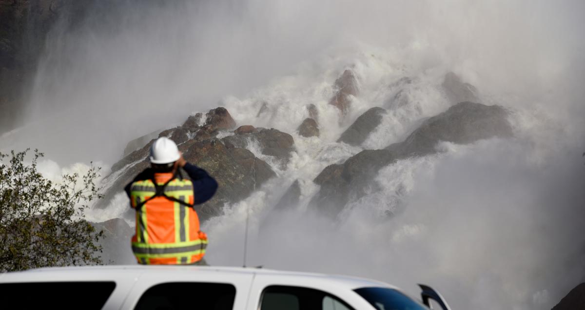
Events of the last week unspooled like the beginning of a disaster movie, with a partial collapse of the Oroville Dam’s main off-ramp for high water, and dangerous erosion beneath an emergency spillway. Almost 200,000 people downstream were evacuated — a precaution in the still-unlikely event the movie ends very badly.
Though mandatory evacuations have been lifted, the dam isn’t out of the woods. Forecasters predict up to a foot of new rain over the next week. Dam operators have spent days preparing for new storms, continuing to spill enough water out of the lake to accommodate incoming rain, according to the California Department of Water Resources. More than 125 construction teams have set about 1,200 tons of rocks and boulders in place to shore up the emergency spillway, and the department is using drone video in addition to on-the-ground monitoring.
The fast pace of events though has obscured a more basic question: Why is California flooding? After all, the last several years have seen combined heat and drought that became so bad that Gov. Jerry Brown declared a state of emergency in 2014.
Weather whiplash, it turns out, is normal in the Golden State, even if this year falls toward the extreme. Conditions in the state are so variable that it’s common to see departures in precipitation of as much as 200 percent from long-term averages. The state experiences most of its rain between October and April. And when it comes down during those months, it can drop in sheets. Meanwhile, April to September are generally dry. It has no analog anywhere else in the continental U.S.
“Drought usually ends in flood in this part of the world,” says Daniel Swain, a UCLA climate scientist, “because that’s what it takes to end them.”
Ask a meteorologist and they’ll explain that California’s big storms come when an “atmospheric river” drops out of the sky. The phenomenon is called the Pineapple Express, a wet, narrow band of air that forms over the tropical Pacific and dumps its wares on Western mountains as snow or rain. The accumulated snowpack acts like a reservoir for the rest of the year’s water, until springtime temperatures melt it, and it flows down into artificial reservoirs, like Lake Oroville.
This winter has been on par with 1982-83, when a powerful El Nino poured moisture into the atmosphere. Currently, California has almost 180 percent of the average snowpack for this time of year.
But snow isn’t the big problem — the big problem is rain. By the beginning of 2017, the state had received more than its normal share of precipitation, but just 50 percent of its average snowpack, according to Michael Dettinger, a research hydrologist for the U.S. Geological Survey. That much rain creates problems for California’s water delivery system: Snow sits there until it’s time to melt. Rain just slides right back down. Into Lake Oroville. All of a sudden.
The new year has brought a relentless pounding. California has been hit by about 10 atmospheric river storms since Jan. 1. By Feb. 7, part of the dam’s main spillway gave out. And this weekend, engineers were concerned that water tipping over an emergency retaining wall was eroding the land beneath it. Imagine, for example, pulling the stopper from a 60 million cubic meter bathtub.
The drought that’s now over for half of California wasn’t the worst the state has ever seen, but it was bad. A high-pressure system — meteorologists jokingly call it the “ridiculously resilient ridge” — parked itself offshore and diverted California’s snow and rain into British Columbia and Alaska. What made it feel like the worst, though, was that the drought coincided with some of the hottest years in recorded history, leading to increased evaporation, a 500-year snowpack low, and subsequent statewide misery.
Yes, climate change plays a role. Heat records are on the march, warmer air holds more moisture, and moisture is ammunition for big-precipitation storms. But the year-to-year variability in California’s climate is so great that it easily swallows up more subtle signals of global warming. Researchers do see these storms intensifying in the future, but for now, Dettinger says, they still fit California’s “really wildly variable precipitation regime.”
April 1 is traditionally the benchmark for measuring snowpack, because it used to be a solid proxy for the seasonal peak. Over the last few decades, snow has begun to melt a week or two earlier, according to Sarah Kapnick, a climate scientist for the National Oceanic and Atmospheric Administration’s research laboratory in Princeton, N.J.
It didn’t take long for the Oroville Dam to become a symbol for America’s aging infrastructure. But the greater challenge is that, in addition to getting older, the nation’s dams, bridges, and roads were constructed for a world that’s receded into the past. Like many U.S. scientists, Kapnick works on improving projections for how the climate may behave just over the horizon — a couple weeks to a couple years — so that California and other regions can better prepare for meteorological madness. But climate change is making a tough job even tougher.
“Everything’s built for a climate from when the major infrastructure projects were happening — decades ago,” she says.