As writer-naturalist John Muir once wrote: “The mountains are calling and I must go.”
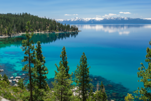
In an annual spring ritual, when warmer weather melts the snow and clears the trails, I get the itch to hike the Sierra, and one of the best places to do that is Lake Tahoe. The largest alpine lake in North America — stretching across El Dorado and Placer counties in California and Douglas County in Nevada — Lake Tahoe is striking not only for its size but also its deep cobalt blue color. Add the granite peaks circling the lake, and you have a classic California postcard view.
Tahoe’s popularity is evident to anyone who visits during the ski season or summer. Traffic is backed up on the interstates leading to the lake and surrounding towns. Hiking is a great way to beat the crowds in the warmer months, as I was reminded during my May visit. My favorite hiking areas in the Tahoe region are Emerald Bay State Park and Desolation Wilderness, both accessed from Highway 89 on the lake’s southwest side. The area was crowded when I arrived, but I was able to find parking on the side of the highway, not far from the start of the Bayview Trail, which leads into Desolation Wilderness.
My plan was to hike up the trail as close as I could to the Sierra Crest, the ridgeline that marks the range’s western boundary, a little more than four miles away, and then return on the same trail. I expected snow to delay or stop my progress, as I could see it covering the mountains in the higher elevations. Despite the crowds on the highway, I passed only a few groups of people on the trail. I heard birdsong — mountain chickadees, stellar jays and song sparrows — and a creek engorged by snowmelt.
Overlooking Lake Tahoe’s Emerald Bay, Eagle Falls is located at
the start of a popular hiking trail into Desolation Wilderness
called the Eagle Lake Trail.

The trail climbs about 2,000 feet but stretches over several miles, making it a relatively easy hike. Most of the trail is forested, and the shade is a blessing in the summer. Lookout spots just off the trail offer views of Emerald Bay, my favorite section of Lake Tahoe. I stopped at one viewpoint and took in the sight: the blue-green bay with a small island in the middle, like the pupil of an eye, surrounded by mountains covered in trees and snow. I continued up the trail. Near Granite Lake, snow stopped me from going further, as it covered the trail and was quite deep. I tried to walk in it, but my leg sank into the snow, almost up to my knee. I turned around and headed back down the trail.
No matter.
I knew there were plenty of other trails at lower elevation free of snow. One option: Eagle Lake Trail, just up the highway, has dramatic waterfalls at the start before leading up to its namesake lake.
I decided to hike part of the Rubicon Trail, which runs alongside Lake Tahoe from D.L. Bliss State Park to Emerald Bay State Park. I parked my car on the highway near the lot for Vikingsholm, an historic Scandinavian-style house that is part of Emerald Bay State Park. A trail from the parking lot goes directly to Vikingsholm and the Rubicon Trail. I took a longer route, down a service road leading to the Rubicon Trail, and it provided great views of the snow-clad Sierra. Before starting on the Rubicon Trail, I stopped to have lunch on a public dock on Emerald Bay. The waves gently rocked the dock as I enjoyed the sights and a sandwich.
I then walked the trail, passing just a handful of people, and marveled at the trees, especially the large sugar pines, that cover the shoreline. I checked out the beach at Vikingsholm and then headed back to my car. I was tired. Lucky for me, I did not have to drive home that day. I had a campsite reserved at Zephyr Cove on Lake Tahoe’s southeast side. I spent several hours reading, relaxing and watching the sunset at the beach. That, too, is a fine way to enjoy Lake Tahoe.
–
Stay up to date on business in the Capital Region: Subscribe to the Comstock’s newsletter today.
Recommended For You

A Cabin in the Woods
Cozy up to these mountain getaways in the Capital Region
On a cold December day, it’s easy to dream about cocooning in a cozy cabin under the pines, fireplace aflame, hands cradled around a steaming mug of cocoa. Think flannel, friends, food and four wooden walls beneath an A-line roof that’s frosted with snow.

Wildflowers and Wildfires Paint Different Scenes in the Sierra Nevada
A recent hike amid the Sierra Nevada mountains prompts Comstock’s president and publisher to consider what can be done in the wake of multiple wildfires and drought.

Saving Lake Tahoe
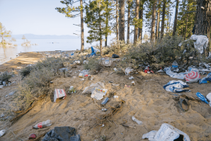
Tourists and the litter they leave behind are threatening the beautiful alpine lake region
Some of the 15 million tourists that visit Lake Tahoe each year are threatening its natural beauty, along with some unruly residents. Now, a new plan is being launched to protect this gem.

Lake Tahoe Is Enjoying Its Best Clarity in 40 Years
While the leaders of the Lake Tahoe region deal with the impact of millions of visitors each year and the trash they leave behind, the lake itself is currently the clearest it has been since the 1980s.


